| Home / China / National News | Tools: Save | Print | E-mail | Most Read |
| China Puts New Navigation Satellite into Orbit |
| Adjust font size: |
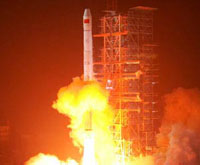
The carrier rocket, Long March 3-A, blasted off at 0:28 AM (Beijing Time). The satellite separated from the rocket about 24 minutes later. Data from the Xi'an satellite monitoring center showed that the satellite had accurately entered its orbit. It is China's fourth Beidou (Big Dipper) navigation experimental satellite in orbit. The previous three were sent in space on October 31, 2000, December 21, 2000 and May 25, 2003 respectively. Experts said the Beidou satellite navigation experimental system is operating well and has played a significant role in cartography, telecommunications, water conservation, transportation, fishery, prospecting, forest fire monitoring and national security. The fourth Beidou navigation satellite, serving as a backup satellite for the Beidou satellite navigation experimental system, may replace the first Beidou satellite, when necessary, continuing to provide all-weather and all-day navigation and positioning information. Experts said China is establishing the Compass Navigation Satellite System on the basis of the Beidou satellite navigation experimental system. The compass system will in 2008 fully meet the demand of satellite navigation for clients in China and neighboring regions. The Compass Navigation Satellite System will gradually extend to be a global satellite navigation and positioning system after network building and experiments, experts said. The compass system will be mainly used for economic purposes, providing efficient navigation and positioning services in transportation, meteorology, petroleum prospecting, forest fire monitoring, disaster forecast, telecommunications and public security, among others. China is one of the several countries in the world capable of developing such a system on its own. The system can help clients know their location at any time and place with accurate longitude, latitude and altitude data. The satellite and carrier rocket were developed respectively by the China Academy of Space Technology and China Academy of Launch Vehicle Technology, which are under the China Aerospace Science and Technology Corporation. The launch represents the 95th flight of China's Long March series of rockets. (Xinhua News Agency February 3, 2007) |
| Tools: Save | Print | E-mail | Most Read |
 |
| Related Stories |